Hidden Gems: Undiscovered Backpacking Routes in California (2025)
Introduction
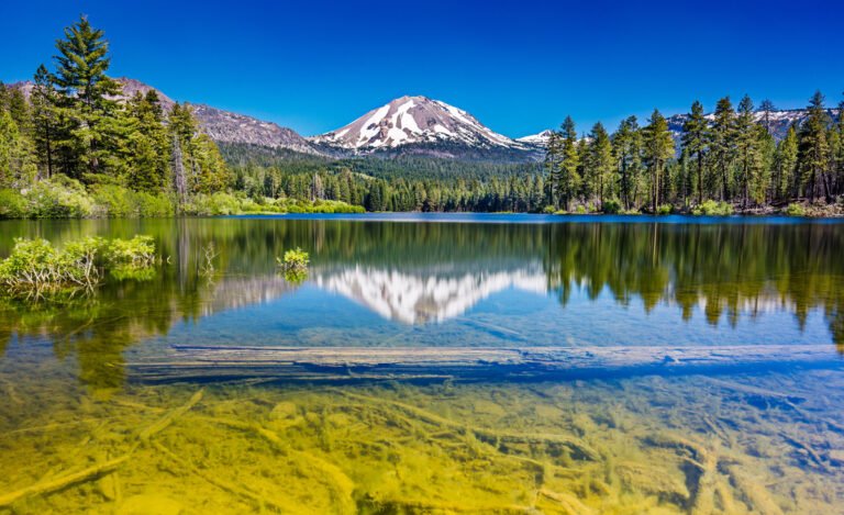
The morning mist was still rising from the valley floor when I crested the unnamed ridge in the eastern Sierra. Three days into my trek of undiscovering backpacking routes in California, I hadn’t seen another soul since leaving the trailhead. As the sun broke through the clouds, illuminating a chain of alpine lakes that seemed to tumble down the mountainside like sapphires, I felt that rare thrill that only comes from discovering something truly special. This wasn’t on any “top 10” list or featured in popular hiking guides. It was my own little piece of California wilderness—at least for the weekend.
California’s outdoor diversity is staggering—from the fog-shrouded redwood forests of the north to the stark beauty of the southern deserts, from the rugged Pacific coastline to the soaring peaks of the Sierra Nevada. While spots like Yosemite Valley and the John Muir Trail have achieved iconic status (and the crowds to match), the true spirit of wilderness adventure often lies in those spaces between the highlighted attractions.
These lesser-known routes offer something increasingly rare in our hyperconnected world: genuine solitude and the feeling of discovery. They provide opportunities to experience California’s natural splendor without the Instagram crowds and permit competitions. They’re places where wildlife behaves naturally, not habituated to human presence, and where the landscape hasn’t been trampled by thousands of boots.
This guide isn’t about the “greatest hits” of California backpacking. You won’t find detailed directions to Half Dome or Mount Whitney here. Instead, I’m sharing routes and regions that have remained relatively obscure despite their incredible beauty—places shared through whispered recommendations from veteran rangers, discovered in the footnotes of outdated guidebooks, or revealed by locals who’ve wandered these lands for generations.
What Makes These Routes "Hidden Gems"
Not every quiet trail deserves the “hidden gem” designation. The routes featured here meet specific criteria that set them apart:
- Low foot traffic: These trails see significantly fewer hikers than their famous counterparts, sometimes just a handful of visitors per week even during peak season.
- Limited online presence: You won’t find countless trip reports or step-by-step guides for these routes on popular hiking websites.
- Local endorsement: Many of these trails came recommended by forestry staff, long-time residents, or veteran backpackers who consider these areas special enough to merit protection through selective sharing.
- Exceptional features: Each route offers something truly remarkable—whether extraordinary vistas, unique geological features, or outstanding biodiversity.
Exploring these pristine environments comes with added responsibility. When visiting less-trafficked areas, adherence to Leave No Trace principles becomes even more crucial. These fragile ecosystems haven’t developed the hardiness that high-use areas sometimes develop. Camp on durable surfaces, pack out all waste, and minimize your impact so these places remain special for the next adventurous soul.
Northern California Treasures
Lost Coast Trail Extension: Beyond the Popular Sections
While the standard Lost Coast Trail between Mattole Beach and Black Sands Beach has gained considerable popularity, few hikers venture beyond into the southern section that extends into the King Range National Conservation Area’s interior. This extended route climbs away from the coast into mixed conifer forests and emerges on breathtaking ridge systems with panoramic Pacific views.
According to the Bureau of Land Management’s visitor statistics, while the main Lost Coast Trail sees over 9,000 visitors annually, this southern extension receives fewer than 500 hikers per year (Bureau of Land Management, 2024).
The route from Horse Mountain Creek to Nadelos Tenting Area offers a stunning 22-mile addition to the traditional coastal hike, with reliable year-round water sources and established (though basic) campsites.
Trinity Alps Wilderness: Canyon Creek Lakes Alternative Routes
The Canyon Creek Lakes trail is the most trafficked route in the Trinity Alps Wilderness, but experienced backpackers can explore the network of unmaintained hunters’ paths that branch eastward toward the imposing Thompson Peak. These routes require solid navigation skills but reward adventurers with access to Boulder Creek Lakes and the Alpine Lake basin—areas where you might not see another hiker for days.
The boulder-strewn landscape here bears striking resemblance to the High Sierra but receives a fraction of the visitors. The area’s flourishing wildlife population includes black bears, mountain lions, and reintroduced Roosevelt elk.
Marble Mountain Wilderness: Sky High Lakes Basin Circuit
Often overshadowed by the nearby Trinity Alps, the Marble Mountain Wilderness harbors some of Northern California’s most spectacular alpine scenery. The Sky High Lakes Basin circuit connects a string of pristine mountain lakes nestled beneath white marble peaks that give the wilderness its name.
The 28-mile loop beginning from the Lovers Camp Trailhead incorporates segments of the Pacific Crest Trail along with lesser-used connector trails. According to Klamath National Forest data, this area receives just 15% of the visitor traffic seen in comparable Sierra Nevada locations (USFS, 2024).
Russian Wilderness: Hidden Lakes and Granite Panoramas
Wedged between the Marble Mountain and Trinity Alps Wildernesses, the compact Russian Wilderness often gets bypassed by hikers heading to its more famous neighbors. This geological wonderland contains 17 named lakes within just 12,000 acres, many accessible only via faint use trails.
The Little Duck Lake Loop traverses high granite basins reminiscent of Yosemite’s high country but sees fewer visitors in an entire season than Yosemite receives in a single day. Hardy backpackers can link together routes from Russian Lake to Waterdog Lake and Big Blue Lake for an unforgettable 4-5 day adventure through terrain that feels truly remote.
Sierra Nevada Secrets
Eastern Sierra’s Great Western Divide: Multi-day Traverse Options
While most Sierra Nevada attention focuses on the John Muir Trail corridor, the Great Western Divide offers multi-day traverse possibilities with comparable grandeur and fraction of the crowds. This massive mountain ridge separates the Kaweah River watershed from the Kern River drainage, creating a natural boundary rich with alpine lakes and 13,000+ foot peaks.
The traverse from Mineral King to Lodgepole via Sawtooth Pass and Black Rock Pass challenges even experienced backpackers with its rugged terrain and significant elevation changes but delivers unparalleled solitude among some of the range’s most dramatic landscapes.
“The Great Western Divide represents some of the most spectacular terrain in the Sierra Nevada that remains relatively untraveled,” notes wilderness ranger Maria Ramirez in the Sequoia National Park backcountry report (NPS, 2024).
Sequoia National Forest: Jennie Lakes Wilderness Loop
Sandwiched between Kings Canyon and Sequoia National Parks, the petite Jennie Lakes Wilderness offers surprisingly remote experiences despite its modest size. The Jennie Lakes Loop combines segments of the Fox Meadow, Jennie Lakes, and Weaver Lake Trails into a spectacular 20-mile circuit that showcases pristine meadows, virgin forests, and crystalline lakes.
This area features many of the same natural characteristics as its neighboring national parks—giant sequoias, alpine meadows, abundant wildlife—without the infrastructure or crowds. According to Forest Service data, for every 100 visitors to Sequoia National Park, only 3 venture into this adjacent wilderness.
Emigrant Wilderness: Lesser-known Lake Chains
Just north of Yosemite, the Emigrant Wilderness features similar breathtaking Sierra Nevada landscapes but with significantly lighter visitation. While popular entry points like Crabtree can get busy, routes exploring the northern lake basins—the Y Meadow Lake and Twin Lakes chains—see minimal traffic.
By starting from the lesser-used Bigelow or Gianelli trailheads, backpackers can create 25-30 mile loops that visit numerous alpine lakes where granite-rimmed basins and pristine waters mirror the surrounding peaks. Many of these lakes still contain wild trout populations, making them excellent destinations for backpacking anglers.
Sierra Backcountry Hot Springs Circuit
For those seeking natural luxury in the backcountry, this specialized itinerary connects several natural hot springs in the eastern Sierra backcountry. Beginning from the Green Creek trailhead near Bridgeport, this ambitious 40-mile circuit visits Buckeye Hot Springs, Barney Lake, Robinson Creek, and connects to several undeveloped thermal pools that don’t appear on most maps.
“The geothermal features of the eastern Sierra represent one of California’s most underappreciated natural resources,” says geologist Dr. Hannah Chen from UC Davis (Sierra Nevada Research Institute, 2023). “Many backcountry springs remain relatively pristine due to their remote locations.”
Central Coast Adventures
Ventana Wilderness: Pine Ridge Trail Variations
The standard Pine Ridge Trail to Sykes Hot Springs closed for several years following fire damage and reopened with restrictions, directing adventure-seekers to discover alternative routes through the magnificent Ventana Wilderness. The connecting network of trails from China Camp and Tassajara Road access points offers multiday journeys through chaparral-covered ridges, redwood-filled canyons, and panoramic coastal viewpoints.
The variants connecting Hiding Canyon Camp to Strawberry Valley create a challenging 32-mile loop with dramatic elevation changes and ecosystem transitions. According to Los Padres National Forest data, visitation to these secondary routes is less than 25% of pre-closure Sykes traffic (USFS, 2024).
Big Sur’s Interior Ridgelines
While coastal Highway 1 draws millions to Big Sur’s dramatic shoreline, the interior ridgeline trails expose a completely different side of this iconic landscape. The Stone Ridge and Logwood Creek connection from Los Padres Dam creates a strenuous but rewarding multi-day journey along remote ridges with expansive views that stretch from the ocean to the interior ranges.
“The interior Big Sur backcountry represents one of the largest coastal wilderness areas in the lower 48 states,” notes conservation biologist Elena Rodriguez. “These watersheds harbor incredible biodiversity, including several species found nowhere else on Earth.” (California Wilderness Coalition, 2024).
Silver Peak Wilderness Routes
South of Big Sur proper, the Silver Peak Wilderness offers a more arid, rugged backcountry experience with significantly fewer visitors. The Cruikshank Trail to Lion Den Camp can be extended into a 3-4 day loop by connecting to the Buckeye Trail, traversing varied terrain from coastal scrub to patches of ancient Santa Lucia fir—a rare tree species endemic to this small region.
This wilderness area provides critical habitat for the endangered California condor, and lucky backpackers might glimpse these massive birds soaring over the ridgelines. The Ventana Wildlife Society reports regular condor activity throughout this range (Ventana Wildlife Society, 2024).
Santa Lucia Mountains: Connecting Trails for Multi-day Adventures
The interior Santa Lucia Mountain range harbors numerous disconnected trail systems that, with proper planning and navigation skills, can be linked into extended backcountry journeys. The Indians Road to Arroyo Seco route traverses some of the range’s most remote terrain, with several abandoned trails that have reverted to challenging but passable routes for experienced backcountry travelers.
This is true wilderness backpacking, where route-finding skills and self-sufficiency are essential. The rewards include visiting historical sites like the Mansfield Cabin, remote swimming holes in the upper San Antonio River, and stands of the rare Santa Lucia fir.
Southern California Discoveries
San Bernardino Mountains: Deep Creek Hot Springs Extended Route
While Deep Creek Hot Springs themselves have gained popularity (sometimes too much), few visitors explore the extended backcountry route that connects the Pacific Crest Trail from Highway 173 in a 38-mile loop through the heart of the San Bernardino Mountains. This route showcases the surprising biodiversity of Southern California’s highest range, transitioning from chaparral to pine forest to riparian corridors.
“The ecological transitions visible on this route demonstrate how Southern California’s mountain ranges function as sky islands—isolated ecological habitats surrounded by completely different lowland environments,” explains Dr. James Morrison of Cal State San Bernardino (CSUSB Environmental Studies, 2024).
Cleveland National Forest: Hidden Waterfall Circuit
San Diego County’s backcountry reveals its secrets to those willing to venture beyond the day-hiking routes. The Eagle Peak-Cedar Creek circuit in Cleveland National Forest strings together several perennial waterfalls—rare treasures in Southern California’s arid landscape. This 25-mile route is best attempted in spring when seasonal creeks flow and the notorious summer heat hasn’t yet arrived.
According to Cleveland National Forest visitor surveys, over 95% of visitors never venture more than two miles from a trailhead, leaving these interior routes nearly deserted even on holiday weekends (USFS, 2023).
San Jacinto Wilderness: Alternative Summit Approaches
While thousands ascend San Jacinto Peak via the Palm Springs Aerial Tramway each year, the mountain’s eastern approaches through Tahquitz Valley offer multiday adventures with spectacular camping opportunities and significantly more solitude. The South Ridge Trail from Idyllwild can be connected to the Caramba Trail and Round Valley for a challenging 27-mile loop that showcases the wilderness area’s remarkable ecological diversity.
“San Jacinto’s eastern face contains some of Southern California’s most pristine montane ecosystems,” notes botanist Dr. Susan Wang. “The sub-alpine forests here represent the southernmost extent of many plant communities typically found much further north.” (California Native Plant Society, 2024).
Anza-Borrego Desert: Secret Canyon Systems
California’s largest state park conceals countless unmarked canyon systems perfect for wilderness backpacking during the cooler months. The Sheep Canyon-Cougar Canyon traverse requires serious navigation skills but rewards adventurers with access to perennial desert springs, Native American pictograph sites, and slot canyons rarely seen by other hikers.
Park archaeologist Miguel Hernandez cautions that these areas require proper preparation: “These remote canyons represent some of the most isolated terrain in Southern California. Visitors should be completely self-sufficient and possess strong navigation skills.” (Anza-Borrego Desert Natural History Association, 2024).
Desert Backpacking Adventures
Death Valley’s High Country Routes
While Death Valley’s reputation focuses on its blistering valley floor, the park’s high country wilderness offers outstanding backpacking opportunities with relatively moderate temperatures for much of the year. The Panimint Range Crest route from Wildrose to Telescope Peak traverses alpine terrain that contradicts everything you might expect from Death Valley, including pine forests and seasonal streams.
“Most visitors never discover that Death Valley contains complete ecological communities ranging from below sea level to nearly 12,000 feet in elevation,” explains park ecologist Dr. Nathan Reynolds. “The biodiversity present across these elevational gradients is extraordinary.” (Death Valley Natural History Association, 2024).
Mojave National Preserve: Volcanic Field Traverse
The Mojave National Preserve harbors volcanic features that rival those of many national parks but receive a fraction of the visitation. The Cinder Cones Wilderness route explores a landscape of ancient lava flows, cinder cones, and Joshua tree forests that feels otherworldly. This challenging 35-mile circuit requires careful water caching but provides access to one of California’s most unique geological landscapes.
According to National Park Service statistics, Mojave National Preserve receives only about 8% of the visitation of nearby Joshua Tree National Park, despite being significantly larger and offering similar desert environments (NPS, 2024).
Joshua Tree’s Outer Boundaries
Most Joshua Tree visitors cluster in the popular rock climbing areas and established campgrounds, leaving vast expanses of the park’s wilderness virtually untouched. The Pinto Basin-Eagle Mountains connection creates a challenging 30-mile backcountry route that explores the park’s eastern wilderness, where the Sonoran and Mojave Desert ecosystems blend in fascinating ways.
This route showcases desert ecology at its most resilient, with unique plant adaptations and wildlife that have evolved to thrive in this harsh environment. Desert bighorn sheep inhabit these remote mountains, though they’re rarely seen by the day-hiking crowds in the park’s popular western sections.
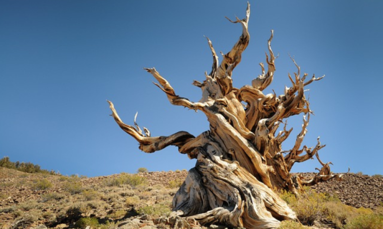
White Mountains: Ancient Bristlecone Forest Loops
Across from the Eastern Sierra lies the less-visited White Mountains, home to the oldest living trees on Earth. Beyond the established Bristlecone Pine Forest interpretive trails, multi-day routes connect the ancient groves via the Cottonwood Creek and Waucoba Springs trails, creating a challenging 28-mile circuit through this high-altitude environment.
“The ancient bristlecone forests represent one of the most significant living archaeological records on the planet,” notes dendrochronologist Dr. Elaine Parker. “Some trees visible from these remote trails were already thousands of years old when the pyramids were built.” (White Mountain Research Center, 2024).


Seasonal Considerations
Timing is everything when planning backcountry adventures in California’s diverse environments. Here’s when to attempt each region for optimal experiences:
Northern California:
- Late June through September offers the most reliable conditions
- Early season (June-July) brings spectacular wildflower displays in mountain meadows
- Fall color peaks in mid-October in many areas, particularly in aspen groves
Sierra Nevada:
- Traditional season runs July through September
- Early season (June-early July) may require snow navigation skills but rewards with rushing waterfalls and fewer crowds
- September and early October often provide perfect conditions with stable weather and fewer visitors
Central Coast:
- October through May is ideal, avoiding summer heat and fire season
- Winter brings lush green hillsides and flowing seasonal streams
- Spring (March-May) features spectacular wildflower displays
Southern California Mountains:
- April-June and September-November offer pleasant temperatures and reliable water sources
- Winter adventures possible at lower elevations
- Avoid summer when temperatures regularly exceed 90°F/32°C
Desert Regions:
- October through April is the only reasonable window for desert backpacking
- Winter (December-February) offers the most comfortable daytime temperatures but requires preparation for freezing nights
- Spring desert wildflower blooms (March-April) provide spectacular scenery in good rainfall years
Water availability remains the primary concern for most California backcountry routes. Trail angels maintain several useful resources tracking seasonal water sources, with the most comprehensive being the California Water Report (updated weekly during hiking season).
Gear Recommendations for California's Diverse Terrain
California’s varied environments demand versatile equipment systems that can handle everything from desert heat to alpine storms. Beyond standard backpacking essentials, consider these specialized recommendations:
Water Management:
- Water capacity of at least 6 liters for desert routes
- Multiple filtration options (primary filter plus backup chemical treatment)
- The Sawyer Squeeze and Katadyn BeFree remain top choices for California conditions according to Pacific Crest Trail Association surveys (PCTA, 2024)
Temperature Regulation:
- Layering systems capable of handling 50°F/28°C temperature swings in a single day
- Desert-specific cooling accessories (sun umbrella, cooling bandanas)
- Sierra-ready insulation even in summer (night temperatures can drop below freezing at higher elevations)
Navigation Tools:
- GPS devices with expanded battery capacity for longer routes
- Custom maps created with CalTopo’s land management overlays to identify wilderness boundaries
- Compass with clinometer for assessing avalanche terrain in early season conditions
Documentation Equipment:
- Weatherproof camera systems (Olympus Tough and Sony RX100 series offer excellent backcountry durability)
- Lightweight tripod for low-light landscape photography
- Extended battery solutions for multi-day documentation
Remember that cellular connectivity remains extremely limited or non-existent in most areas covered in this guide. Satellite communication devices (Garmin InReach, SPOT, Zoleo) are strongly recommended for emergency communication.
Permits and Regulations
Navigating California’s backcountry permit systems requires advance planning and flexibility. Here’s what you need to know for each region:
Northern California:
- Most wilderness areas require permits but don’t have quotas outside popular zones
- Self-issued permits available at many trailheads
- Trinity Alps and Marble Mountain permits available through the Shasta-Trinity National Forest website
Sierra Nevada:
- Competitive quota systems for popular trailheads (reserve 6 months in advance through Recreation.gov)
- Consider “walk-up” permits for less popular entry points
- Sequoia-Kings Canyon wilderness permits include free entry to both national parks
Central Coast:
- Most Ventana Wilderness trails require permits but don’t have quotas
- Fire restrictions frequently impact stove use and camping locations
- Special regulations apply in condor habitat areas
Southern California:
- Adventure Passes required for parking at many trailheads ($5 daily or $30 annual)
- San Jacinto wilderness permits available through Mount San Jacinto State Park
- Cleveland National Forest requires permits for certain high-use areas
Desert Regions:
- Death Valley backcountry permits are free and unlimited but required for overnight stays
- Mojave National Preserve requires permits for specific areas only
- Joshua Tree backcountry registration available at board stations near trailheads
For restricted areas with competitive permits, consider these alternatives:
- Mid-week entry dates see significantly higher permit availability
- Shoulder season applications (early June, late September) have higher success rates
- Alternative entry points accessing the same general areas often have available permits
According to Recreation.gov data, permit applications for popular Sierra Nevada trailheads have increased by over 300% in the past decade, making advance planning increasingly important (USFS, 2023).
Local Insights
The true spirit of these hidden routes often extends beyond the trail itself to the small communities that surround them. Consider these local connections to enhance your journey:
Trail Angels and Community Resources:
- The Eastern Sierra Shuttle Network connects hikers with local drivers for point-to-point hikes
- Trinity Alps trail angel directory maintained by the Harrison Gulch Ranger Station
- Anza-Borrego Desert water cache volunteers (contact the visitor center for current contacts)
Resupply Options:
- Leggett General Store (northern Lost Coast access) offers hiker food caches for a small fee
- Kennedy Meadows Resort (eastern Sierra) accepts and holds resupply packages
- Big Sur River Inn can hold packages for Ventana Wilderness hikers (call in advance)
Local Guide Services:
- Sierra Mountain Center offers custom guided trips to lesser-known areas
- Ventana Wilderness Alliance leads occasional service trips into remote areas
- Mojave Desert Heritage and Cultural Association provides specialized desert hiking information
Community Events:
- Eastern Sierra Interpretive Association hosts monthly naturalist hikes
- Trinity County Historical Society offers historical presentations on mining history
- Anza-Borrego Foundation sponsors desert ecology workshops during peak season
“The trail community surrounding these routes offers knowledge no guidebook can match,” says veteran trail angel Margaret Wilson. “Taking the time to connect with locals almost always leads to better route information and sometimes lifelong friendships.”
FAQs
Q: How do I find these hidden routes if they’re not well-documented online? A: The best resources are ranger stations, specialized guidebooks like “California Wilderness Areas” by Bob Loeffler, and organizations like the California Wilderness Coalition. Building relationships with experienced backpackers in local hiking clubs often leads to shared knowledge of these special places.
Q: Are these routes safe for solo hikers? A: Most routes described here involve genuine wilderness where self-sufficiency is essential. Solo hikers should have extensive experience, leave detailed itineraries with reliable contacts, and carry emergency communication devices. Some routes, particularly in desert environments, are generally not recommended for solo travel.
Q: How difficult is it to navigate these lesser-used trails? A: Navigation difficulty varies significantly. Some routes follow established but lightly-used trails, while others involve cross-country travel requiring strong navigation skills. All backpackers should carry detailed topographic maps, know how to use them, and not rely solely on electronic navigation.
Q: What’s the best approach for water on these routes? A: Research is crucial, as water availability varies dramatically by region and season. Resources like the California Water Report provide updated information on springs and creeks. Desert routes almost always require water caching at strategic points along your journey.
Q: How can I minimize my impact on these fragile areas? A: Follow Leave No Trace principles rigorously, camp on durable surfaces, use established fire rings (where fires are permitted), pack out all waste, and avoid creating new trails or campsites. Consider joining a trail maintenance volunteer day to give back to these special places.
Q: Are these areas more dangerous than popular hiking destinations? A: They can be, primarily because help is further away. These routes generally have much lower visitation, meaning self-rescue or finding assistance from fellow hikers is less likely. Careful preparation, conservative decision-making, and appropriate emergency equipment are essential.
Key Takeaways
- California’s backcountry diversity offers world-class wilderness experiences beyond the famous national parks and trails.
- The most rewarding routes often require additional research, navigation skills, and preparation compared to established destinations.
- Seasonal timing is crucial—each region has optimal windows for exploration that balance weather conditions, water availability, and natural features.
- Building connections with local knowledge sources (ranger stations, outfitters, trail organizations) significantly enhances both planning and on-trail experiences.
- Permit systems vary widely across different land management agencies; understanding the specific requirements for your chosen route is essential.
- Preserving these special places requires responsible practices from every visitor—minimal impact camping, appropriate social media sharing, and support for conservation efforts.
Additional Resources
Specialized Guidebooks:
- “California Desert Trails” by J. Smeaton Chase (historical perspective with enduring value)
- “Sierra South” and “Sierra North” by Kathy Morey and Mike White (comprehensive coverage including lesser-known areas)
- “Trails of the Angeles” by John W. Robinson (detailed coverage of San Gabriel Mountains routes)
Local Outfitters with Specialized Knowledge:
- Sage to Summit (Bishop) – Eastern Sierra specialists
- The Fifth Season (Mt. Shasta) – Northern California expertise
- Real Cheap Sports (Ventura) – Central Coast route information
Online Communities:
- California Hiking and Backpacking (Facebook group with 50,000+ members)
- High Sierra Topix Forums (extensive trip reports and condition updates)
- r/WildernessBackpacking (subreddit with California-specific threads)
Wilderness Office Contacts:
- Inyo National Forest Wilderness Permit Office: (760) 873-2483
- Ventana Wilderness Ranger District: (831) 385-5434
- Death Valley Wilderness Office: (760) 786-3241
- Shasta-Trinity National Forest: (530) 226-2500
Remember that the true value of these remarkable places lies not just in their beauty, but in the experiences they provide—the challenge, the solitude, the connection with something much larger than ourselves. Explore responsibly, tread lightly, and carry the wilderness ethic forward.
This guide was last updated in April 2025. Permit systems and trail conditions can change; always verify current information before your trip.